Reading time : 3 min
When you have to find a lost loved one, you must do so quickly and simply. There’s no time to decipher a map and find your way around, which can sometimes be complicated in a park or in the forest. You need to get straight to the point. Here augmented reality (radar) and the compass come into play. So as not to be disappointed, it is important to understand the limits of these features, to use them in the situations that they are made for.
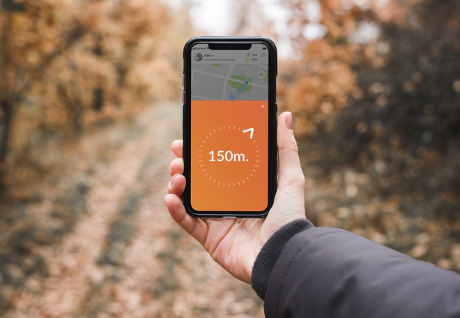
What happens when we request directions? Essentially, we're seeking a computation between two GPS coordinates: the starting point and the destination. It's a similar process when you enable the compass mode on your Weenect application.
The compass and augmented reality (or radar) allow you to simply orient yourself in order to find the tracker. They indicate the direction to take to get to where your locator is, as well as the distance between you and this point. The information provided is updated at each new position of the tracker, for real-time guidance. Note that the super live mode (one position every 10 seconds) is automatically activated when you use the compass or augmented reality, to make it easier to find your loved one.
This data is calculated from the GPS position of your phone as well as the GPS coordinates of the locator. The system calculates the distance between the two positions and the direction from point A (your phone) to point B (the GPS tracker), just like when you are finding your way to the new restaurant you chose with the help of your phone’s navigation application. The only difference is that with the tracker both points are potentially moving, unlike the restaurant which has a defined and fixed location.
The compass amalgamates two margins of error: one from your phone and the other from the tracker. Though negligible at vast distances, these errors can become significant when close, influencing the accuracy of both direction and distance.
All GPS positions have a margin of error of a few meters, this margin is of varying importance, depending on whether you are indoors or outdoors. In the case of augmented reality and the compass, you must take into account that the margin of error is double as the margin of error of the position of your locator is added to that of your phone.
If your loved one is at a significant distance from you, these cumulative margins of error will have only a very small impact on the direction to be taken. On the other hand, if the GPS point you are looking for is about ten meters from you, the direction indicated may be wrong (as well as the distance estimate). This is because at a very short distance the margins of error become more important, like when searching for the tracker that is 10 metres from me (as the tracker itself has a margin of error of 20 metres and my phone has one of 15 metres).
At shorter proximities, the accuracy of tools like the compass or radar might wane. If your loved one isn't in plain sight, rather than relying on these functions, activating the tracker's ringing function is advisable.
At close range, avoid using the compass or radar. Either the carrier of the locator is visible to you and in this case the use of the Weenect application is not necessary, or they are next to you but not visible. In the case of the latter you can activate the ring feature of the tracker, at this short distance the sound will help you locate it.
It could similarly be a case of a child hidden behind a tree, an animal obscured by a bush or a lost tracker that has fallen in the grass. In cases such as these the ring feature will speed up your search. All Weenect features complement each other and can help you in all manner of situations.
As you will have understood, augmented reality and the compass are very useful if and only if the tracker is located at a relatively far distance from you (at least 100 meters). Otherwise, you may find that your plotter is not working or that the Weenect application has a problem whereas you are in fact faced with the limitations of GPS technology. Therefore, when at a short distance it’s best to use the ringtone to aid your search.
To access the most relevant information, suitable payment methods, and delivery in your region, please select the website corresponding to your country.


